
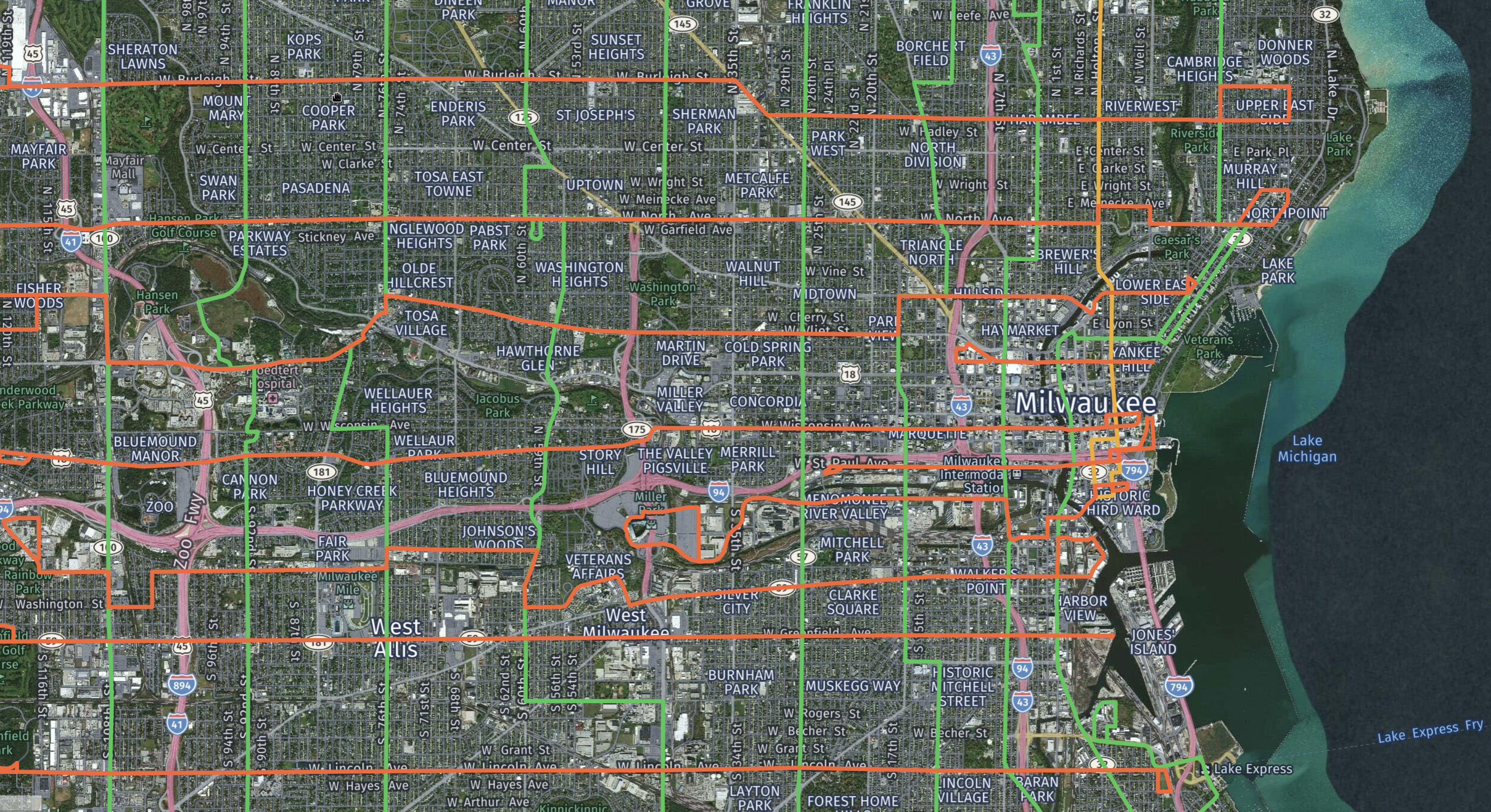
Grid Milwaukee's Bus Routes
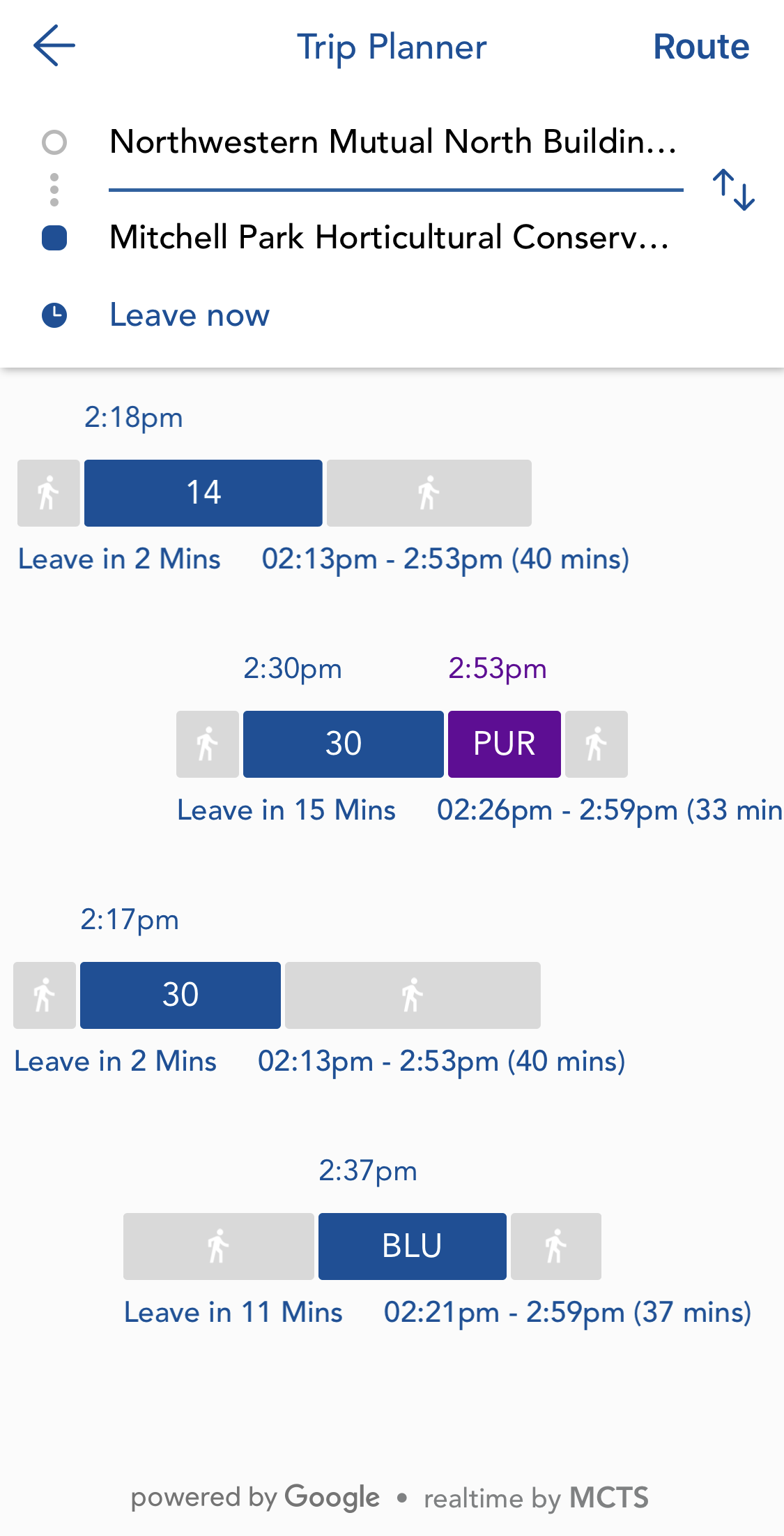
Inspired by an article from Strong Towns discussing Indianapolis' new route trials it provides an alternative system design. To explore a prospective grid patterned map for Milwaukee County click the button above overlaying the map. The orange lines are East-West routes (EW) and the green lines are North-South routes (NS). For the most part each route crosses the entire county from EW or NS. Riding the bus to any destination would require knowing the cross-streets. For example: to get from Northwestern Mutual's new building downtown to the Mitchell Park Domes you would get on a bus at Mason Street / Prospect Avenue (the Wisconsin Avenue turn around), ride west along Wisconsin Avenue and transfer to the 27th Street line heading South. The same route using the existing lines is shown below.
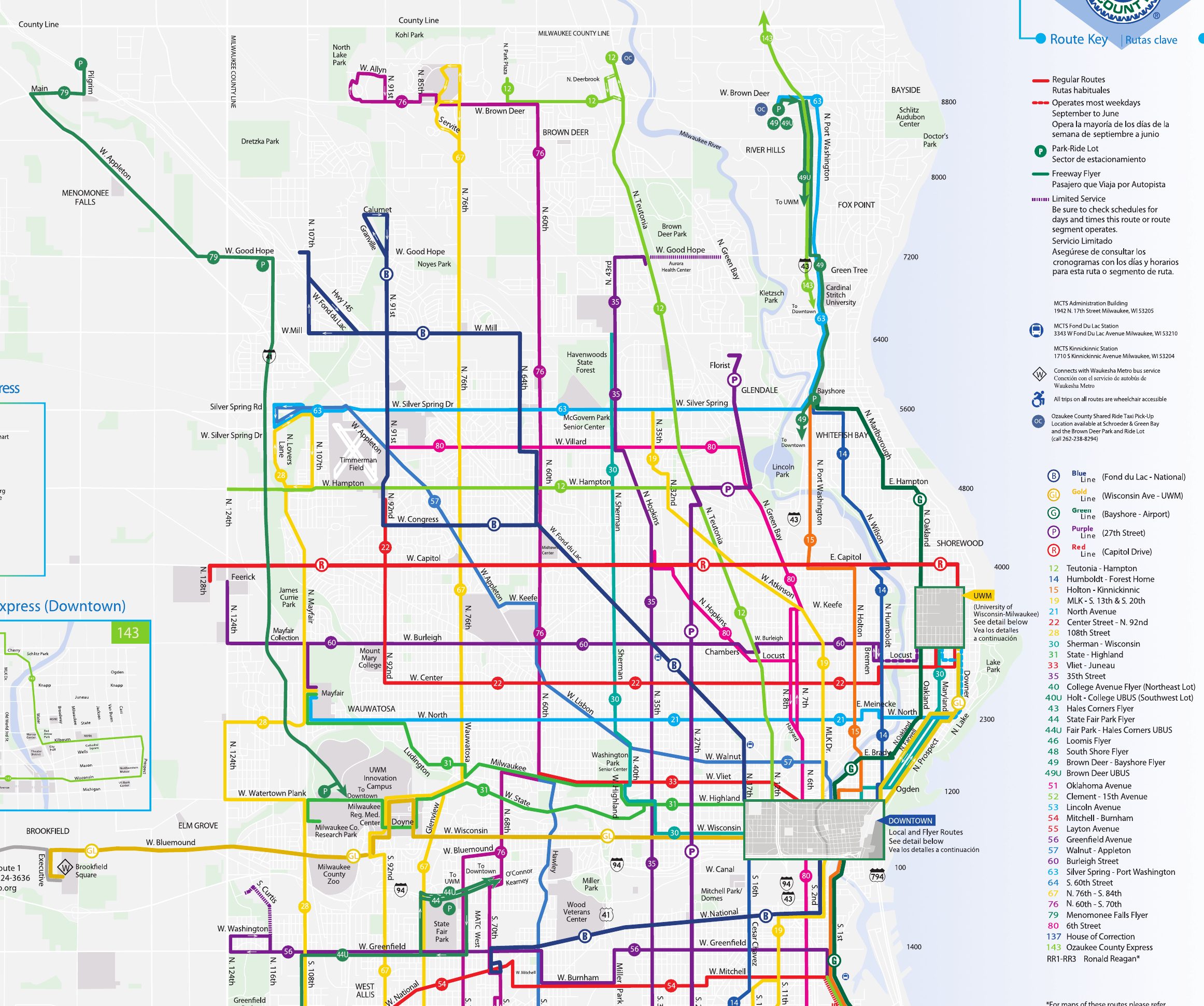
MCTS's existing routes are a bit more sporadic; utilizing a route number or color and destinations (ex: GoldLine Wisconsin Ave - UWM or 21 North Ave.) They have done a good job connecting major amenities but lack the ability to connect riders to every area in the county. Going from Bayside to Brown Deer takes 5-10 minutes by car and 1.5 hours by bus. Franklin and Oak Creek are nearly unreachable. The county's budget is tight every year due mostly to poor pension related decision making from the past so routes have been slowly disappearing or shrinking. MCTS, our county supervisors and our county executive do a good job maintaining the current routes to connect as many people as possible to key destinations (generally prioritizing job access) despite the lack of funds. Unfortunately the current setup appears to create a downward spiral of higher fares and lower ridership (much like the rest of the country.)
Influenced by MCTS advertising and stories about bus drivers, I began riding during the summer of 2019. My wife and I moved from downtown to Bayside a few years ago after which she started a new job in the city. We enjoy eating at various restaurants all around the city (keep it in the county!) so in order to avoid driving two cars home after dinner I decided to start taking the bus down to meet her. MCTS is a great transportation option and I now take the bus to the city multiple times a week. The drivers are friendly, helpful, and know the different routes well enough to help a turned around newcomer (such a myself.) It also encourages me to get outside and walk more. It takes at least 30 minutes to walk to the nearest bus stop from my home. Another example is last fall when I got off at the east end of Brady street and walked west to Van Buren to meet my wife.
The grid map represents what I believe our community should work towards. Every part of the county is fully accessible allowing people to leave their cars at home and get to every part of the county. The general idea at the start was to have each route separated by at most 3 blocks. This was mostly maintained but the south side is more spread out due to limitations of the existing street grid. The bus as a primary mode of transportation becomes practical for virtually everyone and finding your way to a destination is greatly simplified. Every single commercial, industrial and retail area (the jobs) is connected with the grid.
In addition to changing the current routes I believe the county should utilize bus lanes as well as a system that forces traffic lights to change for buses as they approach an intersection; allowing them to maintain a constant speed along each route. This will help maintain a more predictable schedule for riders and speed up trips to further entice new ridership. A bus should pass each stop every 10 or 15 minutes. The stops are not mapped but assume every intersection of a NS and EW route is a stop with only a handful of additional stops needed.
According to Wikipedia, Milwaukee currently has 369 active buses. I have mapped 27 EW routes and 49 NS routes. Assuming 3 buses per EW route 81 buses would be active at any given time. Milwaukee County's shape is tall and thin so the much longer NS routes double the number of buses per route compared with the EW routes. Assuming 6 buses per NS route you would have 294 buses active at any given time. A few individual routes could utilize fewer buses and maintain the same frequency such as West Bradley Road which dies in River Hills where the Milwaukee River blocks its passage.
A few key questions remam unanswered. How many of the currently active 369 buses are in use at any given time? A decent amount probably are rotated regularly in and out of service for maintenance. What is the breakdown of MCTS' $160 million budget? I assume most funding comes from federal grants, county/state funding, with a bit from rider fares (update: fares annually contribute $30,771,208 or 19% of total funding - more than expected!) In my mind income from fares would very likely increase with the grid as more of the county would become accessible and the utility of the system would grow significantly. Why pay all of that money for Uber or Lyft when I can take the bus for $2 (or less!)? Why pay for two cars and maintenance when I can go everywhere with the bus? Has a public private partnership been explored for operating and expanding bus service in our area?
While I personally believe this would be a fantastic system, I can already imagine the push back from those that don't want buses near their homes. It would largely follow the arguments used against apartments, building density or most (revenue generating) change of any kind introduced outside of downtown including crime, noise, environment, etc. It is impossible to improve upon the problems plaguing our area without trying something new.
In the rare instances where our local politicians, against popular opinion, have moved forward with changes that they believe to be in the community's long term best interests these fears never seem to actualize. I still recall the fear from people when Best Buy was proposed for RiverPoint Village near where I grew up. The same arguments were vehemently presented but Best Buy was able to come anyways (probably since it was already zoned for retail.) The area remains largely the same now as it was then and nobody seems to think about or discuss it anymore.
I believe the result of implementing a county-wide grid bus system would follow the same path; a loud opposition followed by everyone adapting to a significantly more useful transportation system that has little to no negative impact on their lives and neighborhoods. As with any idea, there's needs to be leadership that is willing to try things that may be unpopular.
Edit 2020/04/27: Cleanup the intro a bit. Update post with information from the always useful Urban Milwaukee.